

Cayuse, Chinook, Sunrise and Paradise. 114 miles. 13,284 cumulative feet of elevation gain. Break it into two days or run it in a single shot if you're feeling saucy. this herculean route scales the four highest passes of this 14,411 foot cascadian stratovolcano. For those of you keeping score, that is 3,161 feet higher than mount hood, making rainier the highest mountain in the cascades and the most topographically prominent peak in the contiguous united states.
Make no mistake, Rainier is a daunting proposition. The magnitude and scale of the climbs, the volatility of the weather, the fitness buy-in and time commitment all conspire to make this one feel just out of reach much of the year. The payoffs however, make these deterrents seem rather insignificant. We'll start with the terrain. Rocks, cliffs, abundant waterfalls, glaciated valleys, high alpine lakes, massive canyons, icy rivers...this is classic alpine riding at its finest. Then factoring in ultra-smooth pavement, unexpectedly reasonable gradients and meticulously maintained National Park infrastructure, this route quickly moves up the list into our top 3 road rides in the NW.


There are a few different ways to approach Rainier depending on the type of experience you're looking for. These range from absolutely massive 100+ mile/10k+ foot days to relatively gentle 40 mile out-and-back options. Due to the scale and layout of the terrain, the reality is there is no simple way to make a true loop of all the best parts. Redmond Cycling Club's RAMROD literally rides around Mount Rainier in one day, but unfortunately that idea might be better on paper as the killer-to-filler ratio tends drastically toward the latter. To hit all of the biggest and best passes on Rainier, you are presented with a number of out-and-back segments in addition to a Paradise/Longmire/Skate Creek loop. Hitting Cayuse, Chinook, Sunrise and Paradise in a single day is possible, but is best approached as a triple out-and-back to keep the elevation within reason. Of course each of these high pass segments can be done a la carte as well.
The best approach we have found for doing it all is to break it into two days. Cayuse, Chinook and Sunrise the first day and Stevens Canyon to Paradise and the Skate Creek loop the next or vice versa. Ohanapecosh campground makes a great base camp should you choose to break the ride into two days. For single-day riding there are several pull-offs along 123 around Ohanapecosh that serve as solid staging areas. Starting/finishing in Packwood is another good option.
One aspect of Rainier that can be a challenge is the traffic, so timing your ride strategically during low-traffic windows makes for a much better experience. If you can do it midweek and start early, you're going to have the roads to yourself for much of the morning. This also means it's going to be colder w/ the potential for more weather up top, so certainly something to factor in. If you can swing it, the holy grail is riding these roads in the brief window when they are clear of snow and debris yet still closed to car traffic.


Cayuse, Chinook and Sunrise
Cayuse Pass is somewhat of a stepping stone, a utilitarian shoulder and terminus of highway 123 into 410, which ascends the higher and more visually spectacular Chinook Pass, topping out at 5333 feet as Highway 410 skirts Tipsoo Lake and passes beneath Sourdough Gap in a dramatic descent eastward toward Yakima. After an out-and-back through the dreamy horseshoe curves of Chinook Pass, 410 north from Cayuse Pass to Sunrise Park Road is a harrowing 1000 foot drop and easily the least sexy stretch of the route. The pavement is narrow, steep, pitted and crossed by dozens of dicey drainage grates, so descend with caution.
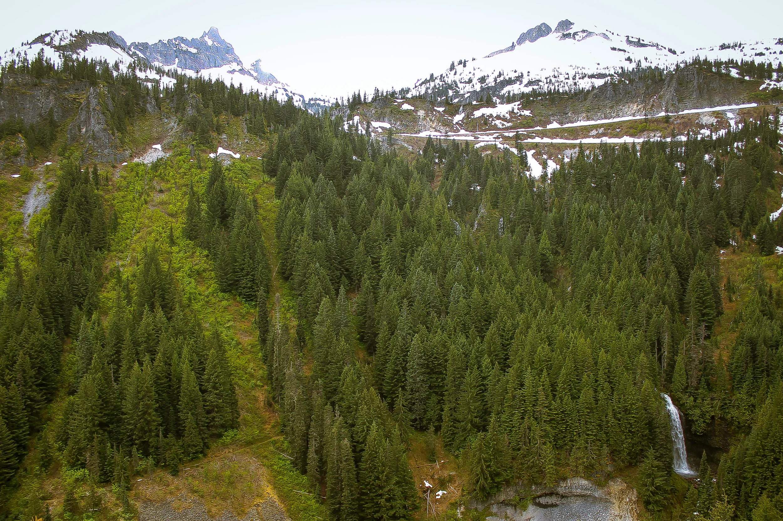
Sunrise tops out at 6400 feet making it the highest paved climb in the park. We had the good fortune of riding Sunrise within the golden window, the roads literally all to ourselves. The climb follows Sunrise Park Road as it winds through the densely forested White River valley, snaking up 15.5 miles of alpine switchbacks, gradually emerging from the treeline to the 360˚ panoramic vistas of Sunrise Point. The scale and perspective is hard to comprehend up here. Rainier physically dominates the field of vision at 14,411 feet flanked by the 13 prominent 6000-7000 foot peaks of the Tatoosh Mountain range. The Sunrise visitors center has a classic weatherbeaten alpine aesthetic and vibe eerily reminiscent of 'The Shining' considering it is snowbound and inaccessible 9 or 10 months a year. The descent from Sunrise is the reward for having climbed 3000 feet in 15 miles. 410 back up to Cayuse is a bit of a harsh puff. It is steep, narrow and can have quite a bit of traffic but relents quickly enough into another blissful ten mile descent to Stevens Canyon.


Stevens Canyon, Paradise, Longmire and Skate Creek Loop
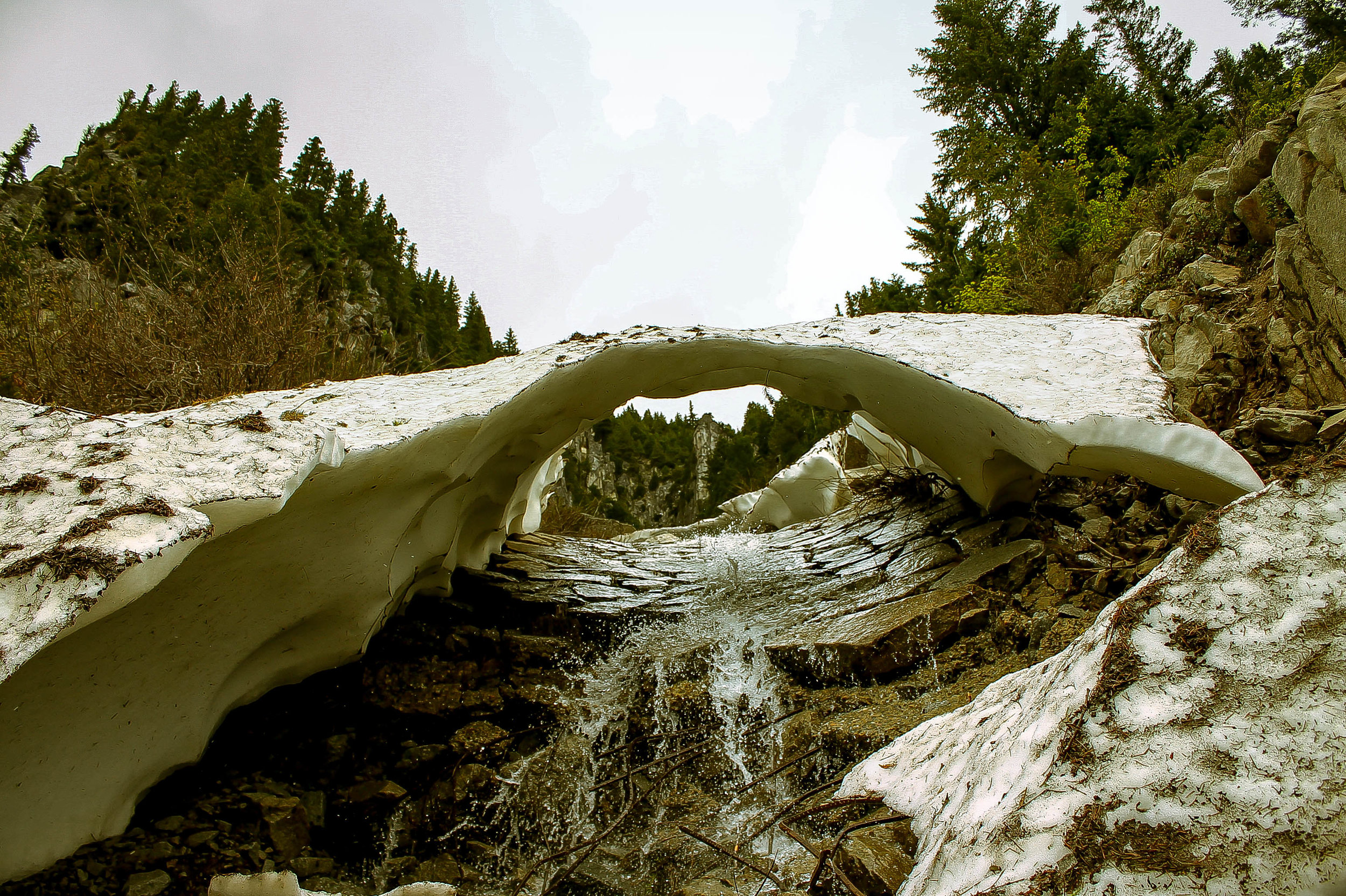
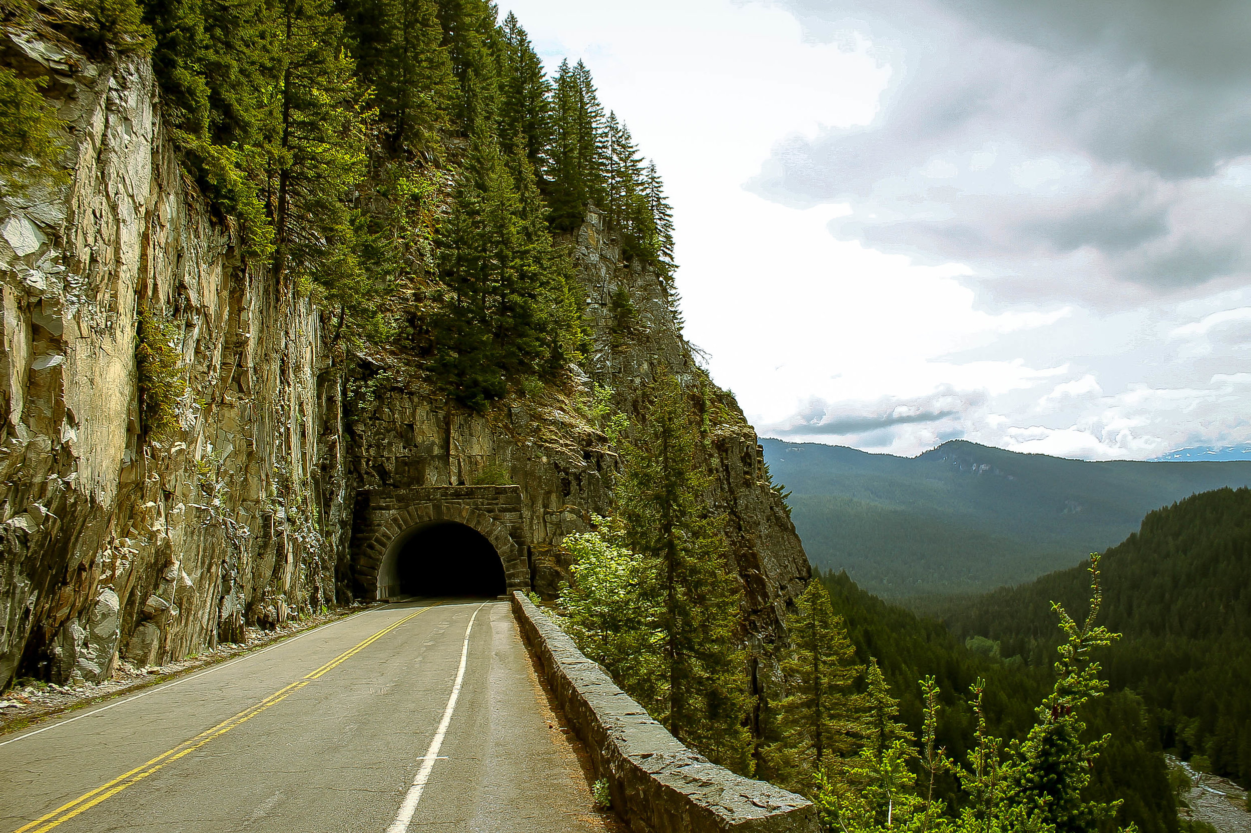
Sunrise may have the sheer elevation but Stevens Canyon is absolutely the crown jewel of the Rainier experience. Designed in the 'rustic style' utilizing classic stone bridges, tunnels, viaducts and retaining walls of National Park architecture in the 1930's Stevens Canyon Highway was not completed until 1957. Climbing east from the Ohanapecosh River through the Grove of the Patriarchs, containing some of the largest stands of old growth Douglas fir, hemlock and cedar in the Cascades, we get a little tease of things to come at Backbone Ridge with a spectacular glimpse of the Tatoosh Range to the south and east. The proliferation of snowmelt runoff waterfalls in the spring and early summer is incredible. We highly recommend bringing a water filter to refill at any number of these fantastic sources.


At Backbone Ridge the climb slackens for a short descent into Box Canyon. Hundreds of thousands of years of runoff from the Cowlitz Glacier has carved this 180 foot deep, 13 foot wide chasm into the andosite bedrock. The Cowlitz and Ohanapecosh Rivers share the unique distinction of being the only two catchments in the park flowing into the Columbia River rather than the Puget Sound. From Box Canyon the climb resumes through one of several roughly hewn rocky tunnels upward into Stevens Canyon.


As the road arcs westward we are plunged headlong into the wide open expanse of Stevens Canyon and the jagged peaks and high alpine meadows of the Tatoosh Range. The ascent intensifies, winding west along high cliff walls, skirting sheer drops, passing beneath overhanging ledges weeping with hundreds of seasonal waterfalls. The views compound around every bend, each impossibly epic sightline topping those previous.
You were promised amazement and Stevens Canyon delivers.


Having experienced Stevens Canyon in all three accessible seasons, the landscape is decidedly the most dynamic in late spring. Moving water is everywhere. Rushing snowmelt creeks gurgle unseen through roadside foliage. Mammoth cascades roar deep in the valley below. Glistening rock faces drizzle fine mists over the roadbed. Surging runoff channels bore deep ravines into the rocky blackness beneath the ashen snowpack. Evidence of catastrophic rock and debris slides is everywhere, the pitted and scarred pavement a testament to the volatility of the landscape.
Rounding the bend over Stevens Creek, the road curves southward and begins to climb out of the valley up the switchbacks toward Bench Lake and Unicorn Peak. The iconic switchbacks rise roughly 1000 feet over three miles evoking the classic European cols of the Alps and Dolomites. Winding upward, the staggering views of the glaciated valley below reveal the magnitude of the climb. The elevation begins to abate approaching a series of high alpine lakes. The stretch between the reflection lakes and Paradise is very popular with tourists and will have a fair amount of traffic in the high season. That said, the monumental sightlines from Inspiration Point of the Tatoosh peaks westward is undoubtedly one of the highlights of the route.


Paradise being the busiest area of the park, contains a visitor center w/ restrooms, water and a cafe as well as the historic Paradise Inn which opened in 1917. Expect RV's, selfie sticks and the usual chaos of high volume tourist traffic. That said the sheer proximity to the vastness of the Rainier glaciers is quite impressive.
Depending on the route configuration the options are either to backtrack through Stevens Canyon as a descent or to continue down Paradise Road East toward Narada Falls, Longmire and the Nisqually gate on the park's west side. In standard Cascadian form, the west-facing slopes tend to be much wetter, mossier, greener and more densely forested. Narada Falls was named by Frederick Gordon Plummer in 1893 after Narada, a Hindi word meaning "pure". There is widespread belief among the Hindu community that Narada Falls shares its name with Narada Muni, a Vedic sage who plays a prominent role in a number of Hinduism's earliest texts.


Paradise Road East is a descent of dreams. Sweeping S-curves, tight cornering, pristine asphalt, it's all here. At mile 38.8 in the loop version of the route there will be a small optional loop to Ricksecker Point with mindblowing views of the Nisqually River Valley, Wilson and Nisqually Glaciers and a full-frontal of Rainier in all of it glory.
Descending along the north bank of the mighty Nisqually River, Paradise Road East sweeps gently though dense shady stands of Douglas fir and velvety moss before exiting the park's west side via the Nisqually gate. The route makes a hard left onto Kernahan Road 3.5 miles west of the Nisqually entrance. Kernahan Road bends eastward tracing the south bank of the Nisqually via Skate Creek Road/NF52, a quietly shaded National Forest Road that meanders through the Gifford Pinchot National Forest gently climbing 21 miles back to Packwood. Depending on your starting point this is either the end of the line or a quick snack stop before pushing on to Ohanapecosh.
This year we've discovered a side door/escape hatch/wormhole portal which connects the backside of Longmire to Skate Creek Road via NF-012. Through the Park Service admin buildings, Longmire Road crosses the Nisqually River and continues south through the campground complex to intersect Skate Creek between miles 64 and 65 in the original routing. This can be a great bailout or shortening option as it essentially shaves 20 miles off the overall loop in the counterclockwise direction. If ridden clockwise, it's a sneaky cut-in straight to Longmire.
Skate Creek Road is a nice departure from the traffic and bustle of the park. It quietly rolls back to Packwood through dense Gifford greenery between the debris-ravaged Nisqually and lush tranquility of Skate Creek. One additional bonus of the Longmire escape hatch is that it cuts out just about all of the backend climbing, which isn't necessarily difficult on its own, but can feel like a bit of a slog after Stevens Canyon and Paradise, so certainly something to keep in mind.


114 MILES
13,284 FEET
ROUTE FORMAT: double out & back...well, technically triple if you count chinook
SURFACE: 100% paved
TIRES: road tires 23c - 28c
BIKE: road
WATER/SERVICES: sunrise visitor's center (july - early sept), paradise visitor's center (weekends only oct - may), ohanapecosh campground/visitor's center (may - early oct)
be aware there is a $10 walk-up/bicycle entrance fee as this is a national park. fees are due upon entry at either the sunrise or stevens canyon gates. pass grants unlimited entry for seven consecutive days
FULL RIDE WITH GPS ROUTE + GPX FILE
** The ALT option below starts/finishes in Packwood, creating a loop that climbs into the park via Stevens Canyon and Paradise. This option descends west via Paradise Road + Longmire exiting the park via the Nisqually gate. This version loops back to Packwood via Skate Creek Road/NF-52. This is a great option for breaking the larger route into two days.
78.2 MILES
6562 FEET
ROUTE FORMAT: loop
SURFACE: 100% PAVED
TIRES: ROAD TIRES 23C - 28C
BIKE: ROAD
full ride with gps route + gpx file

Terms of Use: As with each adventure route guide published on OMTM.CC, should you choose to cycle this route, do so at your own risk. Prior to setting out check current local weather, conditions, and land/road closures. While riding, obey all public and private land use restrictions and rules, carry proper safety and navigational equipment, and of course, follow the #leavenotrace guidelines. The information found herein is simply a planning resource to be used as a point of inspiration in conjunction with your own due-diligence. In spite of the fact that this route, associated GPS track (GPX and maps), and all route guidelines were prepared under diligent research by the specified contributor and/or contributors, the accuracy of such and judgement of the author is not guaranteed. OMTM.CC, its partners, associates, and contributors are in no way liable for personal injury, damage to personal property, or any other such situation that might happen to individual riders cycling or following this route.