
Deer Park is a compact climb straight into the heart of the Olympic Range. One road up. One road down. 6181 feet over 41 miles. an epic alpine climb in every sense of the word, deer park traverses classic olympic landscapes through lush, velvety moss-covered forests, climbing above the treeline among exposed rocky peaks, high alpine valleys and meadows with expansive views of the strait of juan de fuca and beyond to vancouver island.

Dense, difficult, massive, looming, glaciated and 95% designated wilderness, the Olympics have always felt intimidating and somehow impenetrable. From Seattle, they are a visual constant, looming snowcapped just to the west. Though they seem close, they can be logistically difficult and time-consuming to reach between the ferries, islands, waterways and long drives. Hurricane Ridge gets the lion's share of the visitors, being one of the very few roads into the high elevation areas. Deer Park on the other hand is a bit of a deep cut, located on the quiet northeastern edge of the park. While the Olympics are best known for the Pacific Coastline and temperate rainforest, some of the wettest areas in the continental US, receiving an average of 150 inches of rainfall, Deer Park is located in a dry rainshadow with only 16 inches of rain annually.


Staging out of Port Angeles, this updated version of the route utilizes the Olympic Discovery Trail to sidestep highway 101, running along the waterfront to connect with lower Deer Park Road. The climb begins by heading south through an unlikely light industrial-suburban zone but quickly settles into quiet rural rollers, gently winding their way up the looming foothills of the Olympics.

Deer Park's lower tarmac rollers climb through patchwork parcels of old clearcut in varying stages of regrowth. Pavement ends at mile 11.9 as signage indicates entry into Olympic National Park though there is no guard station or checkpoint. The well-maintained gravel weaves gently through idyllic evergreen forest carpeted w/ dense velvety moss looping elegant curves upward as the gradients steepen. Tracing expanding contours we are privy to some wonderful breakout sightlines to Rocky Peak, Mount Angeles and Hurricane Ridge to the east and the rocky, treeless Blue Mountain saddle, which is where we are headed. The rainshadow element becomes very real around 4000 feet as we break out of the trees into broad expanses of steep, dry rocky flaxencolored bunchgrass rimmed with intense red, orange and yellow understory coming into peak autumnal plumage as of the time of this ride. Views up and downvalley confirm that we've climbed a fuckton in a relatively contracted distance. That we're not really feeling overly fatigued seems to be the magic of unbelievable vistas at work.


We approach the Deer Park parking area which doubles as the easternmost endpoint to the Obstruction Point trail, which I will regard with a slice of mock contempt. The proximity to Obstruction Point is only 7.5 miles via pristine mountain singletrack...infinitely rideable...but the Wilderness Act of 1964 sets these trails off-limits to anything but foot traffic by Federal mandate.
“A wilderness, in contrast with those areas where man and his works dominate the landscape, is hereby
recognized as an area where the earth and its community of life are untrammeled by man”
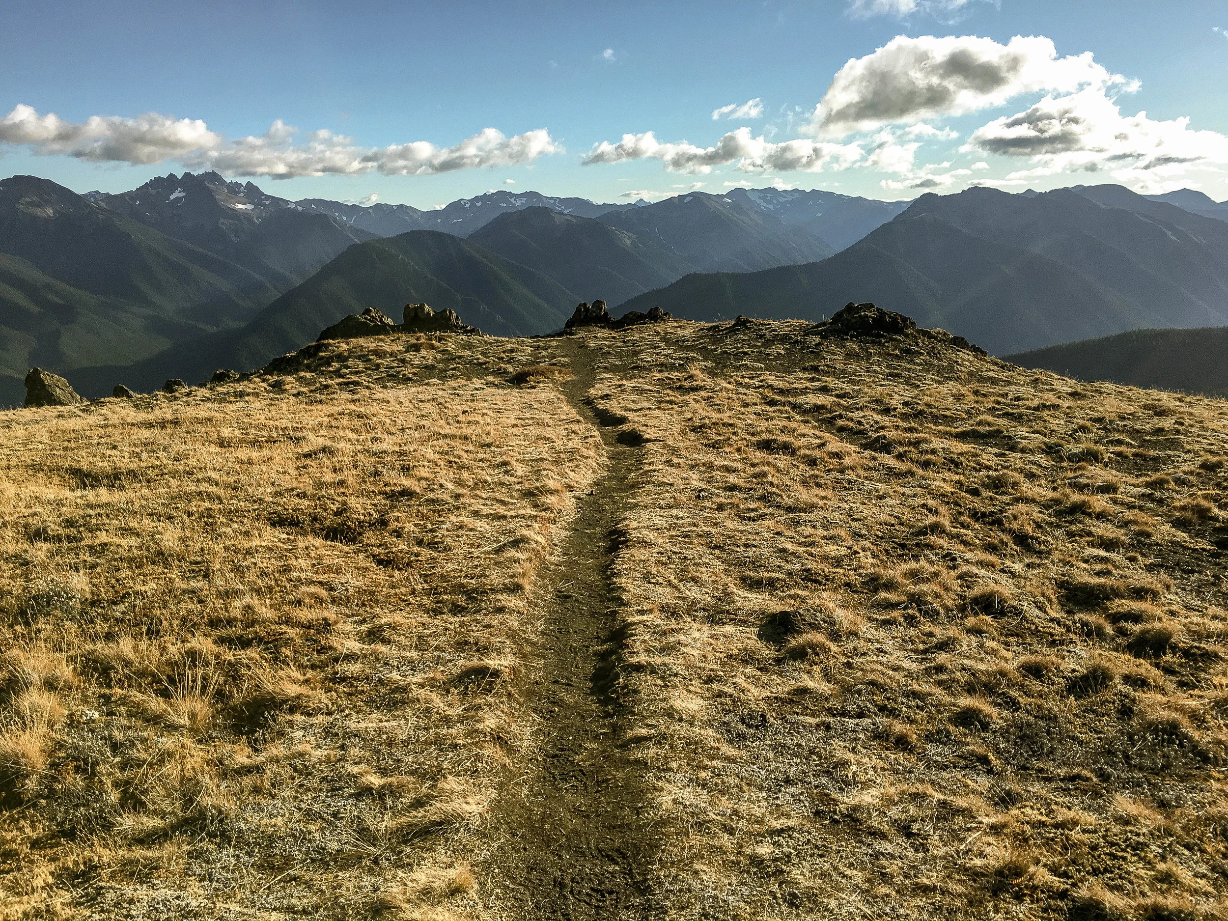
And that is alright. We support that idea as the allowance of any non-primitive recreation obviously opens the door to a veritable Pandora's Box of competing usage interests. So we'll regard Obstruction Point as a destination for another day and continue climbing. Beyond the campground Deer Park road emerges from the treeline onto the windswept bunchgrass shoulders of Blue Mountain. A pair of dramatic switchback climbs remain before reaching the Blue Mountain summit trailhead. The views northward along the Blue Mountain saddle are incredible. This is technically the end of the line for bikes. From here it is just a short hop to the summit with 360 degree views of the Olympic Range skyline to the west, Straight of Juan de Fuca and Vancouver Island, BC to the North and well, all the other Cascadian goodness across the Puget Sound to the east. I find it a lovely spot to pontificate on one's sense of scale, conjure grand plans of 'doing this kind of thing more often' or simply mulling over the meaning of it all whilst enjoying a cold one. It's a long descent. You're going to want something warm in your belly.


A couple of notes about the descent, watch for washboarding in the corners, things can get pretty bone-rattling at the end of the dry season. Though this is the quieter side of the park be aware that this road does see a moderate amount of traffic in the high season, so watch the blind right-hand corners on the way down. Other than that, you know what they say about an A-shaped out-and-back: business up front, party in the back!
Enjoy.
44 MILES
6328 FEET
ROUTE FORMAT: OUT & BACK
Season: late spring through mid-fall
SURFACE: 50% GRAVEL, DIRT AND ROCK, 50% PAVED
TIRES: MINIMUM OF 33C. 40C+ RECOMMENDED
BIKE: CYCLOCROSS/GRAVEL/RIGID 29ER/MTB
WATER/SERVICES: NO SERVICES. WATER FILTER REQUIRED.
FULL RIDE WITH GPS ROUTE + GPX FILE
Terms of Use: As with each adventure route guide published on OMTM.CC, should you choose to cycle this route, do so at your own risk. Prior to setting out check current local weather, conditions, and land/road closures. While riding, obey all public and private land use restrictions and rules, carry proper safety and navigational equipment, and of course, follow the #leavenotrace guidelines. The information found herein is simply a planning resource to be used as a point of inspiration in conjunction with your own due-diligence. In spite of the fact that this route, associated GPS track (GPX and maps), and all route guidelines were prepared under diligent research by the specified contributor and/or contributors, the accuracy of such and judgement of the author is not guaranteed. OMTM.CC, its partners, associates, and contributors are in no way liable for personal injury, damage to personal property, or any other such situation that might happen to individual riders cycling or following this route.