

in a frantic race to complete what was once thought impossible, two competing railroad companies, james hill's Oregon Trunk railroad and the Deschutes Railroad company, owned by edward harriman, began construction on opposing lines at the confluence of the Deschutes and Columbia rivers. hill on the western side, harriman on the east. These railways would parallel each other through the inhospitable Deschutes River canyon with the goal of connecting the columbia to bend. By midsummer 1909, both railroad operations were blasting their way through the steep volcanic basalt rock canyon encasing the river and ultimately into a head-on collision that would be recorded as the last great railroad war in America.

There are tales of rampant sabotage, gunfights, railcars tipped into the river, boulders rolled, black powder blown, even sacks of rattlesnakes ruthlessly planted in opposing camps. Every cartoonish page from the Wil E. Coyote playbook was employed in this infamous scrap between turn-of-the-century railroad barons. What does this have to do with bicycle riding? Well, seeing as the Oregon Trunk Railroad eventually emerged victorious, the tracks currently in use running along the west side of the river are the modern and functional iteration of Hill's Oregon Trunk line, the railroad grade Harriman blasted along the eastern wall of the canyon now exists as the roadbed of the Deschutes River Trail or DRT. In its current state the DRT runs from the mouth of the Deschutes southward, tracing the arc of the river which bisects not only the iconic elephantine landforms of the region but articulates the boundary between Wasco and Sherman counties.
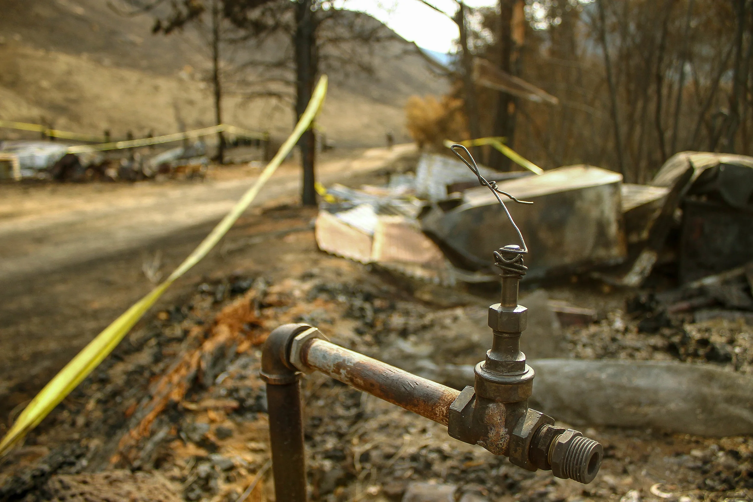
By the numbers, the primary out-and-back version of the DRT is about as simple as they come, essentially a flat 19.2 miles one way, a 38.4 mile round trip. An entry-level bikepacking overnight or a straightforward day trip, the DRT provides a metric fuckton of bang for your buck, with a virtual overload of accessible Oregon high desert magic. From the north end, the trail surface alternates between gravel road, sandy doubletrack and rugged desert path growing wilder as the roadbed pushes south beneath crumbling walls of sunbaked volcanic rock, the river powerfully twisting, bending and slicing through intense canyonforms and rimrock. This zone is classic Central Oregon high desert which means two things are guaranteed in abundance: rattlesnakes and goatheads. The north end of the canyon is outfitted with surprisingly consistent state recreational area restrooms, five total, dotting the primitive camping areas all the way to the Harris Ranch complex, the charred remains of a 19th century homestead which, until this past July, contained a handful of dilapidated farm structures, corrals, cattle-chutes, sheds, small barns and collapsed farmhouse.


* Before and after images from above Harris Canyon, pre and post burn.
A curious sidespur appears at mile 11.6 near the remains of the Harris Canyon water tower. Harris Canyon Road switchbacks sharply up to the left then back, winding eastward along the severe, narrowing hillsides of Sayrs Canyon, eventually dwindling to interlaced gametrails as the roadbed roughens, climbing beyond into Jackass Canyon. There are a few isolated camp spots up here if you know where to look. An interesting diversion, but it is perhaps an adventure for another day. Back on the main trail, the grade becomes decidedly rockier beyond Harris Canyon continuing about 7.5 more miles before the 'official' DRT dead-ends unceremoniously at mile 19.2 at the first of six yawning, boulderstrewn canyons once spanned by Harriman's railroad trestles.

This is where things get interesting. For most, this is the end of the line and the sensible turnaround. However for a certain grade of rider looking for a gamier cut, perhaps wanting to take things a bit further, the unmaintained railroad grade does present an opportunity to continue 4.5 miles to connect with the BLM access road at Macks Canyon, onward to Sherar's Bridge Highway (216) and Maupin, 9 miles to the south via Deschutes River Road. This is not to say the going is easy. The missing link traversal to (or from) Macks Canyon is a raw, rugged stretch many attempt but few complete. Six gaping canyons of sundry severity lie along this rough patch between the end of the DRT and Macks Canyon. Where some see rubblestrewn flumes of sunscorched hardscrabble misery, others find a challenging dose of solitude and awe-inspiring wildness. One person's trash is another person's treasure. In any case, this option is certainly not for everybody.


Notwithstanding the six ravines, a relatively consistent loose, primitive trail winds through the rubble, skirting deteriorating railroad ties, windblown bunchgrass, intermittent fields of sunbaked rock and sagebrush pulsing with insects. The trail surface runs the gamut from relatively rideable singletrack to jagged piles of boulders calving from unstable canyon walls to steep Andean-style switchbacks in and out of deep canyon washes. All in all, the traverse in not so technically difficult as it is simply time-consuming. It is also remote being 19 miles deep from the north and 17 miles in from the south. Traversal of this missing link however, opens up a range of possibilities involving larger thru-touring connectivity to Maupin, Tygh Valley and points beyond, also allowing for any number of single day loops such as the east or west halves of the Oregon Stampede circuit using the Deschutes River routing as either the start or finish.


If you are thinking about pushing through there are a few factors to consider:
Bike weight: The connection requires a considerable amount of push and portage. A lightweight, minimal setup will make things much easier. 2" plus is ideal, either MTB or drop bar 'adventure bike' without bags will be the best case scenario. A fully-loaded multi-day bikepacking rig will take a bit more determination and time. But of course, all of this is predicated on how this section works in the overall context of any given ride plan.

Tires: The proliferation of goatheads in the region dictates that running tubeless is essential for just about any significant off-pavement riding east of The Dalles. The DRT is certainly no exception. The fruit of the Tribulus terrestris, a desert annual of the caltrop family, also known as devil's weed, puncturevine or bindii, goatheads will puncture just about anything running tubes. Due to the tiny size of the thorns however, tubeless tires are very effective at self-sealing the micropunctures, thus neutralizing the threat. Trust me. I've learned this the hard way.
Footwear: I think it goes without saying that you're pretty deep in SPD/rugged MTB shoe territory by this point. Road shoes will make absolutely no sense out here. Another decent approach is flat pedals w/ hiking shoes, this clearly depends on the broader scope of the ride and what makes the most efficient sense for the most amount of time in the saddle.
Water: The closest available water is in the Deschutes River State Rec Area campground on the north end and in Maupin or Tygh Valley on the south end, so plan accordingly. Clean filterable water sources are scarce in the region, so plan ahead. Pro-Tip #1: there are spigots in White River Falls State Park, but cannot attest to seasonal availability. Anything less than three full bottles between Tygh Valley and Deschutes River Rec Area, if you're planning to push through above 85 degrees is a bad idea unless you are prepared to filter the river.
The river is the obvious choice for filtering, but given the amount of runoff from agricultural plateaus upriver, we wouldn't recommend it. Pro Tip #2: soak your cap, jersey, gloves, kerchief at any opportunity along the river. Hell, dunk your junk or just go for a swim, it will go a long way toward keeping your core temps down in hot weather.

That was then.
This is now.
In July of 2018, the Substation and Long Hollow fires ripped through the borderlands of Wasco and Sherman counties, ravaging the Deschutes River valley and adjacent agricultural plateaus from Dufur to the periphery of the Dalles. The entire Harris Ranch compound was destroyed, including Harris Canyon water tower and historic boxcar structures. Driven by strong winds and abnormally high temperatures, the fires consumed over 80,000 acres of bunchgrass prairie and wheatfield before being contained.


I will leave the specifics on the destructive and regenerative properties of fire and nature to better-informed parties but will note that I was astonished at how quickly new growth is taking shape. The eradication of foliage has thrown the contours of the landscape into dramatic relief, vascular human and gametrail networks intertwining with newfound clarity. The indomitable growth of grasses and shrubs pushing up through the ashes are a visual bellwether of a landscape in flux.


Classic Deschutes River Trail
38.3 MILES
1483 FEET
ROUTE FORMAT: out and back
SEASON: Spring, fall, winter
SURFACE: 100% unpaved
TIRES: 40C PLUS tubeless RECOMMENDED
BIKE: CYCLOCROSS/GRAVEL/ADVENTURE/ALLROAD
FULL RIDE WITH GPS ROUTE + TCX FILE
Deschutes River Trail to maupin
50 MILES
2317 FEET
ROUTE FORMAT: out and back/loop segment
SEASON: Spring, fall, winter
SURFACE: 75% unpaved, 25% paved
TIRES: 2" PLUS tubeless RECOMMENDED
BIKE: ADVENTURE/ALLROAD/mtb
FULL RIDE WITH GPS ROUTE + TCX FILE

Terms of Use: As with each adventure route guide published on OMTM.CC, should you choose to cycle this route, do so at your own risk. Prior to setting out check current local weather, conditions, and land/road closures. While riding, obey all public and private land use restrictions and rules, carry proper safety and navigational equipment, and of course, follow the #leavenotrace guidelines. The information found herein is simply a planning resource to be used as a point of inspiration in conjunction with your own due-diligence. In spite of the fact that this route, associated GPS track (GPX and maps), and all route guidelines were prepared under diligent research by the specified contributor and/or contributors, the accuracy of such and judgement of the author is not guaranteed. OMTM.CC, its partners, associates, and contributors are in no way liable for personal injury, damage to personal property, or any other such situation that might happen to individual riders cycling or following this route.