

nestled between North Cascades national park, the Methow Valley and Pasayten Wilderness, Slate Peak towers above a serrated skyline amid hundreds of craggy glacier-crowned summits at the east end of the most rugged mountain range in the lower 48. an exercise in superlatives and accessed by the highest maintained road in the state of washington, slate peak tops out at 7488 feet.
cool, right?
To clarify, Slate Peak and Hart's Pass are two different destinations along the same road, closely situated, but separated by about three miles and 1200 feet. The road to Hart's Pass was built in 1893. Let that sink in for a minute. Eighteen fucking ninety three. Let's see, what was going on in 1893..horses, hand shovels, pickaxes, dynamite and some insane hardscrabble living. At any rate, this incredible road was chiseled into the mountains during the Northwestern mining boom en route to Chancellor and Barron claims, now ghost towns, Cady and Windy Passes and dozens of other abandoned mining operations home to roughly 3000 people at the peak of the gold and silver rush just prior to 1900. During the Cold War Slate Peak was designed to serve as radar defense warning against incoming foreign threats which never materialized. Again, it was abandoned and now exists a minor historical footnote amid this massive and absurdly magnificent landscape.


Slate Peak/Hart's Pass had been on our shortlist of holy grail rides for a couple of years, however located in north-central Washington, 20-some miles from the Canadian border and our being Portland-based, it took a while for the opportunity to present itself. For all of its epic surroundings, the climb itself is actually rather gentle. Starting in Mazama, it's 21.5 miles up and 21.5 miles back down w/ 5500 feet of gain. The Mazama Store makes a natural start/finish point w/ great espresso, craft brews and surprisingly refined snacks, bakery and camp goods.
Setting out westward along Lost River Road, a gentle paved stretch reminiscent of Western Montana's dry ponderosa pines and reddish soil, the pavement ends shortly after crossing the Lost River around mile 7, rolling through shady campgrounds and quiet creeks along the Methow River. Things hairpin right at mile 9 following NF5400, switching back and quickly gaining elevation above the valley floor.


Around mile 12, we break out of the trees at Deadhorse Point into a series of harrowing curves, rubble strewn rock faces and precipitous cliffs dropping steeply to the valley floor. This section bears the scars of multiple catastrophic slides, winter avalanches and subsequent roadwork. Also a popular snowmobile route in the winter, this spot is particularly dicey and prone to frequent slides. Each spring one or two snow machines are recovered from the valley below having failed to navigate the sidehill traverse around Deadhorse Point.

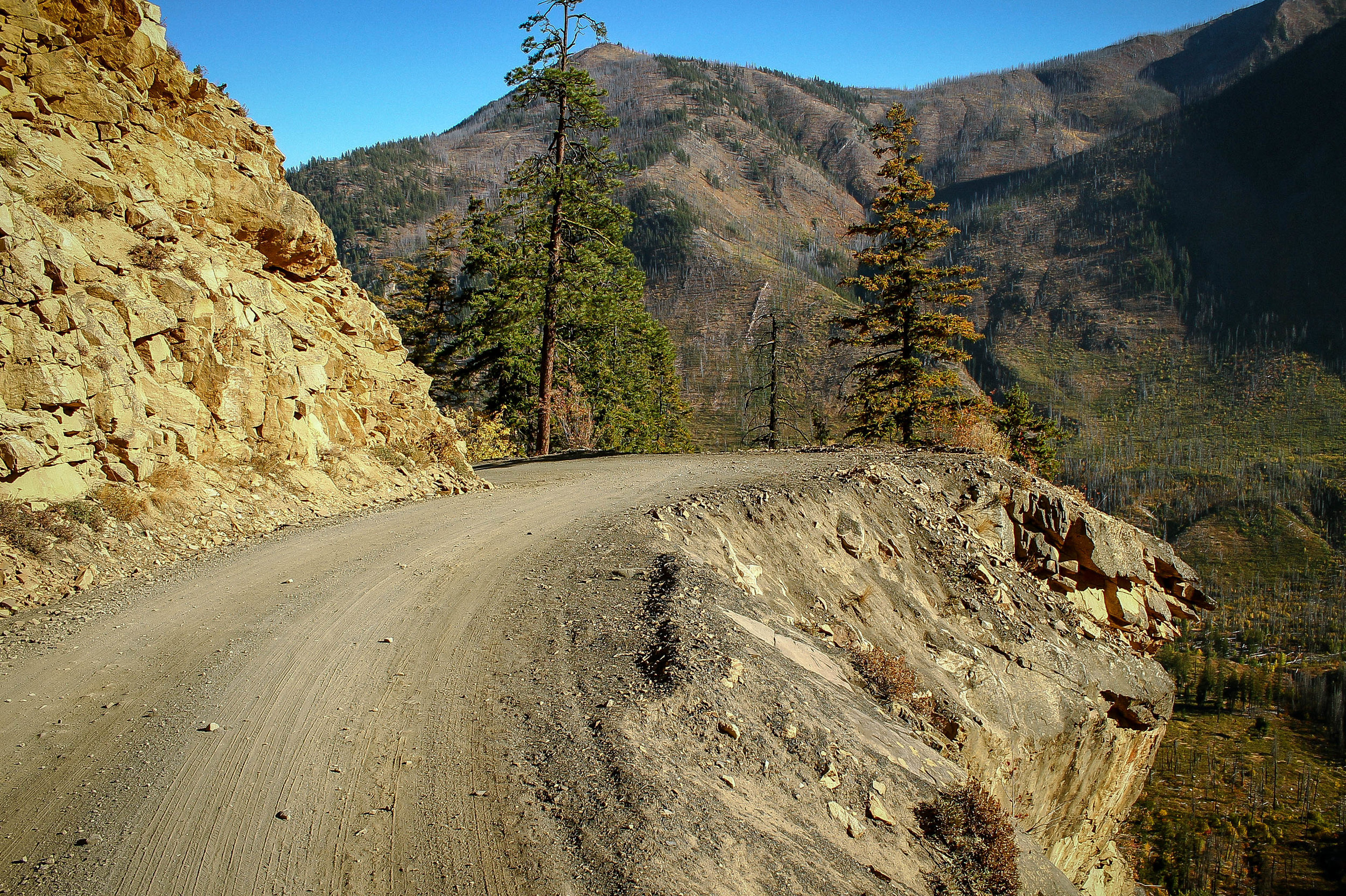
The views are of course, ridiculous. Deep glaciated cliff walls drop over a thousand feet to the Methow River below. Pushing onward, the valley tightens curving northward along Rattlesnake Creek, climbing higher through radiant autumnal hues bristling with sunbleached spires of deadwood forests long since burned.
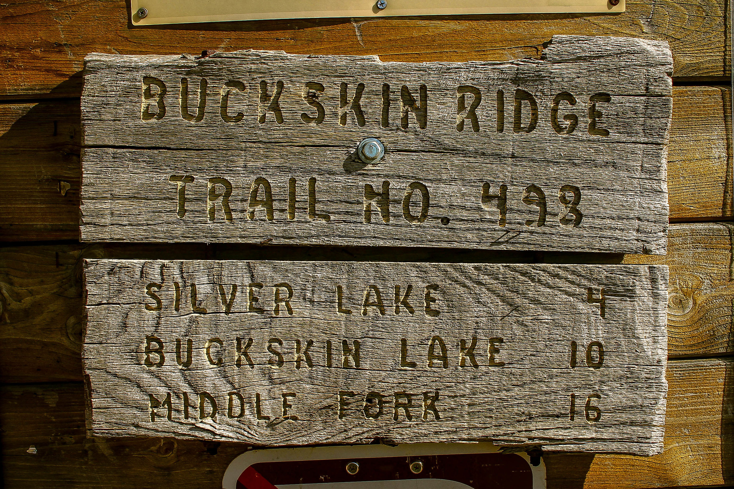
NF5400 continues upward approaching Hart's Pass at 6100 feet. At a crossroads of sorts I was surprised to find a weathered 1940's era Forest Service Guard Station and campground. Signs indicate Slate Peak is 3 miles north and Chancellor 9 miles west, the road to which appears more traveled than expected and skirts the edge of the Pacific Crest Trail, which is always a good sign. I have heard the road to Chancellor is now gated, which certainly sweetens the deal for further exploration.


As with many of these big climbs, the magic is all in the final few miles. The road from Hart's Pass upward to Slate Peak becomes noticeably rougher with more embedded rock. Climbing out of the treeline beneath Slate Pass, the scale and grandeur of this massive glaciated valley begins to set in. Doubling back in a series of dramatic horseshoe curves, the road snakes upward through stands of radiant golden larches in peak color. A peculiar sensation of scale and distance, foreground and background begin to shift, features that loomed large begin to feel impossibly distant, seemingly indomitable peaks and ridges recede into valleys, falling into hazy relief, joining dozens of other peaks and ridges in a blue-grey sea of summits stretching to the horizon on all sides.


The last push to the summit is a 1/4 mile climb of 16-18% gradient surfaced with chunky rock to a leveled surface w/ the remnants of the 1950's era radar station and lookout tower. The skyline is absolutely humbling in all directions. 360 degrees of sawtooth peaks as far as the eye can see. Conditions at the top can extremely windy and volatile, so come prepared for quite a range of weather and temperature conditions.
The out-and-back orientation of this route allows for quite a bit of time absorbing the environment from multiple vantage points as things look and feel quite different on a climb than a descent of this magnitude. It's easy to let loose on the way back down. Keep an eye out for embedded rock and ruts in the upper section and be mindful of the washboarding all the way down, it's fairly easy to get a bit loose and several of the corners have zero margin for error.

While we've just provided the basic Slate Peak route here, the larger area is ripe for further exploration and can be configured into any number of multi-day variations involving Barron and Chancellor ghost towns, Windy Pass, Cady Pass and beyond. One thing to note is that while much of the mining history in the area is relegated to the past there are actually a few active claims that are still being worked by a handful of hardscrabble hermit types who are notoriously prickly, so just be aware of the potential for things to get a bit weird if pushing further west on NF700 toward Chancellor and Barron.
As I mentioned, Mazama Store makes for an ideal start/finish for explorations into the Hart's Pass area. It's got a great vibe and a solid deck for beers, espresso and sandwiches.
43 MILES
5508 FEET
ROUTE FORMAT: out & back
SURFACE: 90% gravel, dirt and rock, 10% paved
TIRES: MINIMUM OF 33C. 40C+ recommended
BIKE: CYCLOCROSS/GRAVEL/RIGID 29ER/MTB
WATER/SERVICES: NO SERVICES. WATER FILTER REQUIRED.
FULL RIDE WITH GPS ROUTE + GPX FILE
Terms of Use: As with each adventure route guide published on OMTM.CC, should you choose to cycle this route, do so at your own risk. Prior to setting out check current local weather, conditions, and land/road closures. While riding, obey all public and private land use restrictions and rules, carry proper safety and navigational equipment, and of course, follow the #leavenotrace guidelines. The information found herein is simply a planning resource to be used as a point of inspiration in conjunction with your own due-diligence. In spite of the fact that this route, associated GPS track (GPX and maps), and all route guidelines were prepared under diligent research by the specified contributor and/or contributors, the accuracy of such and judgement of the author is not guaranteed. OMTM.CC, its partners, associates, and contributors are in no way liable for personal injury, damage to personal property, or any other such situation that might happen to individual riders cycling or following this route.